ホーム > 観光・名産 > 観光・レジャー > 観光・名所 > 観光情報ひろば湘南 > Walk along Enoshima-michi and Oyama-michi(Part 2:Tsujido to Hiratsuka・Tamura)
更新日:2026年1月13日
ここから本文です。
Walk along Enoshima-michi and Oyama-michi(Part 2:Tsujido to Hiratsuka・Tamura)
湘南地域のモデルコースをご紹介しています。
(This course is the Tsujido to Hiratsuka・Tamura leg of the course from Enoshima to Oyama.)
During the Edo Period, “Oyama-mairi,” or climbing the mountain to pray, was very popular among the general public.
When the population of Edo was one million, about 200,000 people visited Mt. Oyama every year.
It was common to journey to worship the goddess Benzaiten in Enoshima after worshiping the god of Mt. Oyama, so much that there is a classical rakugo story about Oyama-mairi.
This course does the opposite, going from Enoshima to Oyama.
It is difficult now to follow the exact path that was used, but this course will take you from Tsujido to Hiratsuka・Tamura using signposts and other markers.
In Part 1, we introduced a course from Enoshima to Tsujido. This time, the course is from Tsujido to Tamura in Hiratsuka City.
Course guide
JR Tsujido Station
▼ approx. 5-min. by bus ▼
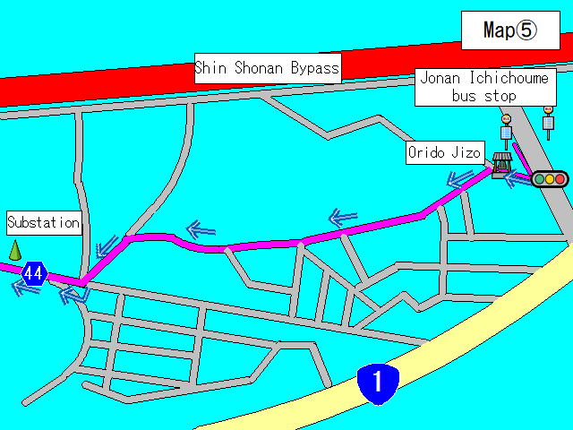
Jonan Ichichome bus stop
This is the last bus stop from Part 1. We start from here.
There are many branching roads, so refer to Map (5)(JPG:73KB) as you go.
▼ approx. 1-min. walk ▼
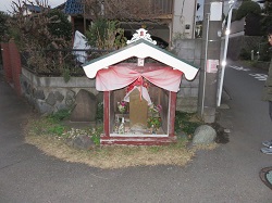
Orido Jizo
Located where the road splits in two.
Take the road on the left as shown in Map (5)(JPG:73KB).
▼ approx. 6-min. walk ▼
There is complicated branching. Proceed according to Map (5)(JPG:73KB) and take Prefectural Route 44.
▼ approx. 21-min. walk(Prefectural Route 44) ▼
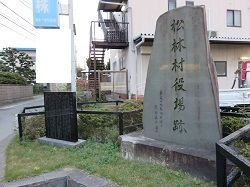
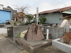
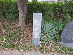
Shorin Village Office Monument
There is an inscription about Oyama-michi on the stone monument.
▼ approx. 3-min. walk(Prefectural Route 44) ▼
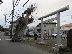
Shinmei Okami Shrine torii gate
The entrance to Akabane Shinmei Okami Shrine, said to have been built by Minamoto No Yoshiie.
▼ approx. 2-min. walk(Prefectural Route 44) ▼
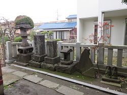
Six Jizo of Akabane
There is a memorial stone for the Oyama-kaido road in the cemetery in the back.
▼ approx. 4-min. walk(Prefectural Route 44) ▼
Kumano Shrine
Founded as a branch shrine of Kumano-hongu Shrine (Kii Province) by Tadataka, the father of Ooka Tadasuke (governor of Echizen Province).
▼ approx. 2-min. walk ▼
Takada Intersection
Get off Prefectural Route 44 here.
▼ approx. 5-min. walk ▼
Intersection at Matsukazedai
The road has several more branches ahead.
Proceed according to Map (6)(JPG:72KB).
▼ approx. 15-min. walk ▼
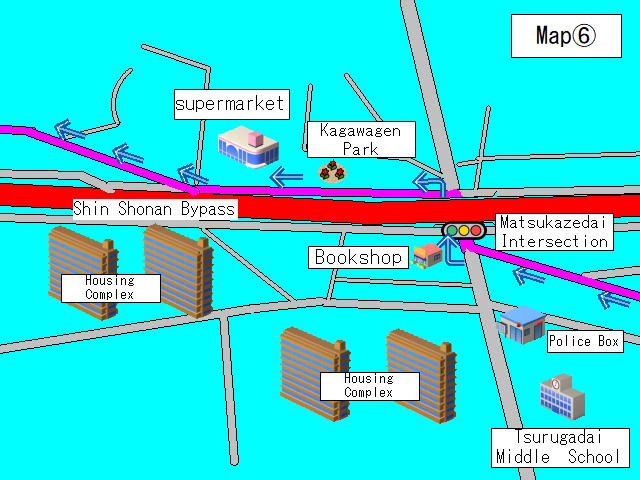
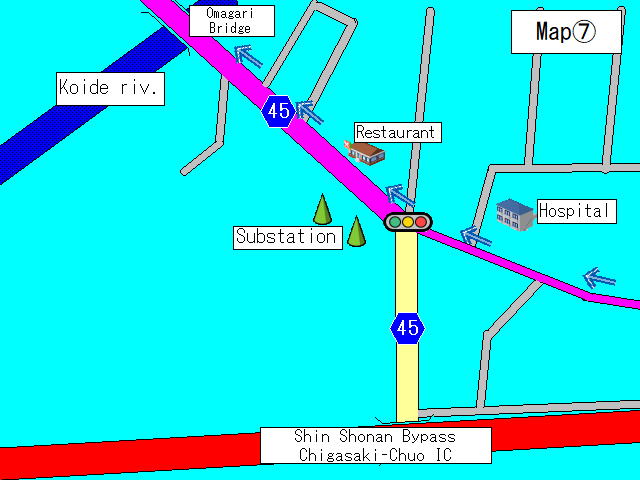
Merge onto Prefectural Route 45
As shown on Map (7)(JPG:54KB) ,the road merges with Prefectural Route 45 here.
▼ approx. 2-min. walk(Prefectural Route 45) ▼
Omagari Bridge
This is said to be the birthplace of the folktale “Kappa and the Sake Flask.”
▼ approx. 18-min. walk(Prefectural Route 45) ▼
Keikan Temple
Things to see include the pagoda and the statue of Kobo Daishi.
▼ approx. 2-min. walk(Prefectural Route 45) ▼
Ichinomiya Hachiman Shrine
There is a large torii gate on the side of the road.
You’ll also find many stone sculptures, including night lamps, behind the shrine.
▼ approx. 4-min. walk(Prefectural Route 45) ▼
Matsudo Bridge stone marker
This is where a bridge used to stand when there was a river running through here.
▼ approx. 4-min. walk(Prefectural Route 45) ▼
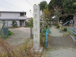
Ichinomiya Tenmangu Shrine (former site of Kajiwara Kagetoki’s house)
This is the former site of the house of Kajiwara Kagetoki, chief retainer of Minamoto no Yoritomo.
▼ approx. 1-min. walk(Prefectural Route 45) ▼
Intersection at the entrance to Ichinomiya Elementary School
Here you take Prefectural Route 47.
▼ approx. 7-min. walk(Prefectural Route 47) ▼
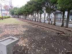
Hakkaku Square
This is the former site of Nishi-Samukawa Station on the Sagami Line.
Part of the rails from that time remain.
▼ approx. 2-min. walk(Prefectural Route 47) ▼
Ichinomiya Fudodo
There is a signpost along the road and is inscribed with the word “Oyama-michi.”
▼ approx. 14-min. walk(Prefectural Route 47) ▼
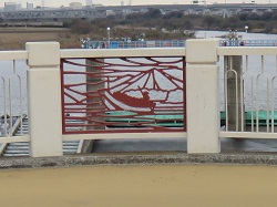
Kamikawa Bridge
Along the bridge, you’ll find plates inscribed with the words “Oyama Kaido,” “Tamura Ferry,” and “To Enoshima,” as well as a bridge rail designed to resemble a ferry.
▼ approx. 3-min. walk ▼
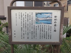
Former Tamura Ferry site
If you cross the Kamikawa Bridge and walk downstream on the river bank, you’ll find stone monuments, informational signs, monuments inscribed with a poem, and other objects.
▼ approx. 2-min. walk ▼
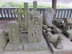
Yasaka Shrine
If you walk upstream and go under the Kamikawa Bridge, you’ll find Yasaka Shrine and several stone sculptures. Among these, you’ll find a signpost that reads “Oyama-michi.”
▼ approx. 5-min. walk(Prefectural Route 47) ▼
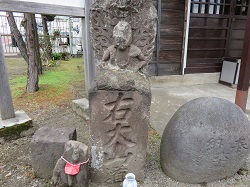
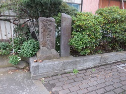
Oyama signpost
Beside the Kyutamurajujiro Intersection, there is a signpost inscribed with the word “Oyama-michi.” In that same place, there is also the Juodo monument that was erected to memorialize those who died in battles on the Sagami River.
▼ approx. 2-min. walk ▼
Tamurajujiro bus stop
Take a left at the Kyutamurajujiro Intersection, and about two minutes down the road you will find the Tamurajujiro bus stop.
Part 2 ends here.
(Part 3 and more will be posted later.)
このページに関するお問い合わせ先
企画調整部 商工観光課
電話 0463-45-3193
このページの所管所属は 湘南地域県政総合センターです。